I. INTRODUCTION
The purpose of this study is to discuss the need for the establishment of Electronic Culture Atlas on old roads in Gyeonggi Province and the concept of providing information. The Gyeonggiyetgil is a “road for walking” created by Gyeonggi Province for citizens. Gyeonggiyetgil (https://ggcr.kr/).
During the Joseon Dynasty, the Gyeonggiyetgil was constructed based on six road networks that passed through Gyeonggi-do among the roads connected to the provinces around Seoul. Starting with Suwon and Hwaseong-gil of Samnam-gil in 2012, the city aims to open all the old roads in Gyeonggi-province by 2022.
Gyeonggiyetgil has been used since the Joseon Dynasty, so there are many cultural heritages and stories to date. There are also research achievements related to the old road of Gyeonggi-province. There is an era map showing the old road of Gyeonggi-province. Gyeonggiyetgil, where such various information exists, provides information on Gyeonggiyetgil-Website and Gyeonggiyetgil-App.
The Gyeonggiyetgil-App provides voice guidance, guidance, and completion stamps for hikers who actually walk along the old road in Gyeonggi Province. The Gyeonggiyetgil-Website (https://ggcr.kr/) provides services such as introduction of old roads in Gyeonggi Province, stories of old roads in Gyeonggi Province, walking programs on old roads in Gyeonggi Province, and online newsletters.
Data on Gyeonggiyetgil provided by the Gyeonggiyetgil-App and the Gyeonggiyetgil-Website are provided for pedestrians who are ordinary people and want to walk along the old road in Gyeonggi Province. Therefore, various professional data on the old road of business are not being serviced. The purpose of this study is to analyze the characteristics of oral records of contributors to sports development to find the direction of big data research on oral records of contributors to sports development in the future.
However, various information is expected to exist as Gyeonggiyetgil has been used by hikers since the Joseon Dynasty. We would like to discuss the necessity of establishing an electronic culture map of Gyeonggi-province and the concept of providing information as a tool to collect and utilize such information.
The research on electronic culture maps was conducted in literature, history, and geography areas such as Kim Heung-Kyu, Shin Hang-Soo, Oh Hang-Nyeong, Lee Hyung-Dae, Kwon Soon-Hwoei, Woo Eung-Soon, Her Yong-Ho, Kim Sun-Hee, and Kim Jong-hyuk [1].
Lee Hyungdae considered the characteristics of the electronic cultural Atlas and how to use it as a knowledge map [2]. Michael Buckland and Lewis Lancaster Lewis Lancaster studied electronic cultural Atlas. They Formed the Electronic Cultural Atlas Initiative and created dynamic maps, an exchange of shared data sets accessible through a map-based interface, format and content standards for geographical names and period lists, research to improve the geotemporal aspects of online catalogs, dynamic Created best practice guidelines for preparing electronic publications with geo-time marks [3].
Jisun Byun built the Seoul Village Gut electronic cultural map based on the Choseon Culture Electronic Atlas [1, 4].
Jonghyuk Kim viewed the electronic cultural map as a new research method to study the humanities in the digital age [5].
In addition, there are studies on the theory and actual construction of electronic cultural maps of Korean Intangible Cultural Heritage, studies on Sulhwa Literature Map [3]. And Mind Humanities and Electronic Culture Map [4]. There is a study on the electronic cultural map design plan for Korean dance, which is an intangible cultural asset [5]. Jaehoon Jeong judged the electronic cultural map constructed in Korea in the following three ways. This is Time Map KOREA, a Atlas of Korean history built and provided by ECAI, an electronic cultural map of the Joseon Dynasty and the Korea Local Culture Exhibition [6].
Baek Hyun-gi researhed a map of the humanities of mind[7]. K. H. Kim, J. Y. Kim, J. Y. Yoo, and H. S. Baek created an electronic dance culture map [8].
J. H. Jeong researched the Silk Road database and electronic cultural map building [9].
Among the Electronic culture Atlas already implemented, the Joseon Dynasty electronic cultural maps produced by the Korea University Institute of National Culture are examples of convergence research by researchers from various majors protecting their respective majors[10]. The electronic cultural map of the Joseon Dynasty is a database that constructs cultural information from the Joseon Dynasty to the modern and contemporary era on the axis of time, space, and theme. This map shows the changes and extinction of various themes around the three axes from the Joseon Dynasty to modern times, and these patterns are marked on the map to infer the cultural changes of a particular region, relationships with neighboring areas, and influences in the entire space of the Korean Peninsula. Among the themes of this map, Village Gut (shaman ritual) Electronic Culture Map was divided into the units of “Natural Village” to build and provide information.
This study aims to discuss the basic concept of providing information necessary to build an electronic cultural map of the old road in Gyeonggi Province based on the Joseon Dynasty, which contains vast amounts of information on three axes: time, space, and theme.
II. THE NEED FOR ELECTRONIC CULTURAL GUIDANCE ON OLD ROADS IN GYEONGGI PROVINCE
Gyeonggiyetgil is a road built based on six road networks that pass through Gyeonggi-do Province, which connects Seoul to the provinces during the Joseon Dynasty. The old road of Gyeonggi-do has existed since the Joseon Dynasty to the present day. This road may be marked on a map, and maps produced by time include information on the old roads of Gyeonggi-do. Therefore, if a time-by-time map including the old road could be provided on the web, more diverse information could be provided about the old road. A map by time is an electronic cultural map that has the function of overlapping several maps produced by time based on a specific region.
Let’s look at the following map. Fig. 1 shows map of Gyunggiyetgil.
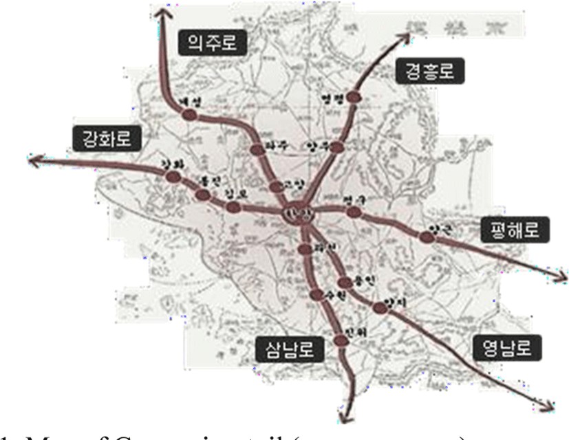
The roads shown on the map above are Samnam-gil, Uiju- gil, Yeongnam-gil, Pyeonghae-gil, Gyeongheung-gil, and Ganghwa-gil. Uiju-ro, which is indicated on the map above, is a route to the north of the Korean Peninsula, centering on Seoul. Gyeongheung-ro is the way to the northeast around Seoul. Ganghwa-ro is the way to the west around Seoul. Samnam-ro is the way to the southwest around Seoul. Yeongnam-ro is the way to the southeast around Seoul. Pyeonghae-ro is the way to the east around Seoul.
As such, the six roads of the old road in Gyeonggi-do Province are six directions centered on Seoul and are important to and from Seoul from province Seoul. Therefore, in the past, when horses and walking were the mainstream, many people would have passed this road and come and go. There are also various cultural heritages on the road. For example, Samnam-gil has many cultural heritages, including Princess Sukhwi’s tomb, Goyanghyanggyo(school of Confusion in Goyang), and Pajuhyanggyo(school of Confusion in Paju). In addition to tangible heritage, there are many intangible heritage such as ancestral ritual and Ritual of Confuse.
Let’s look at the map below. Fig. 2. shows Chosun culture electronic Atlas.
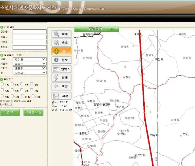
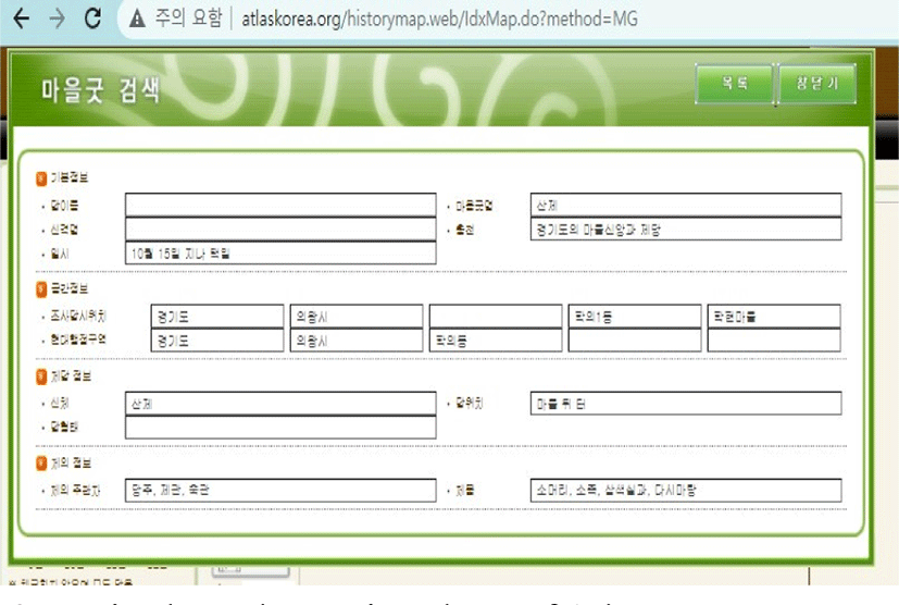
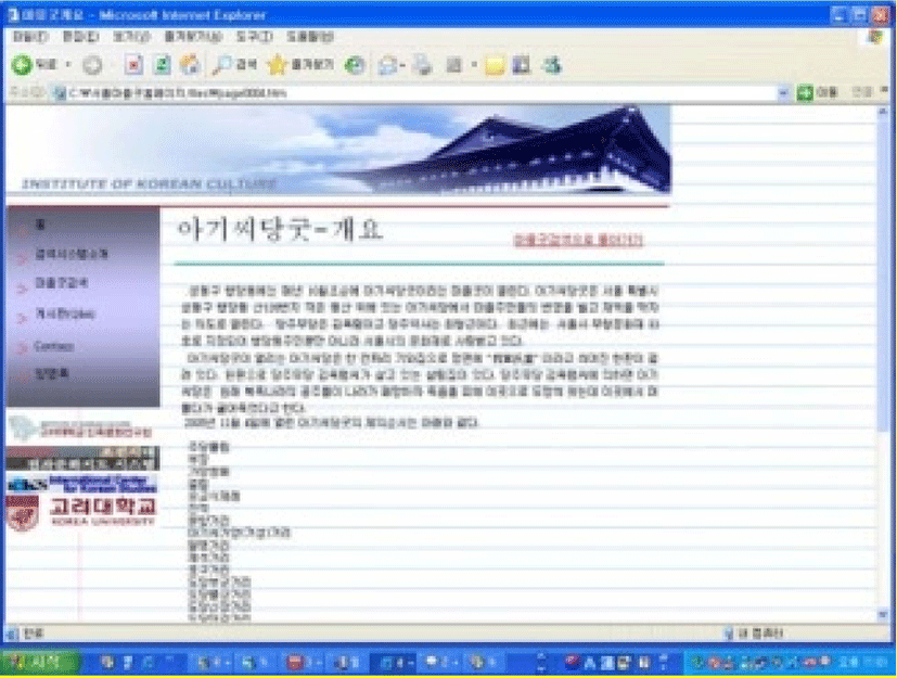
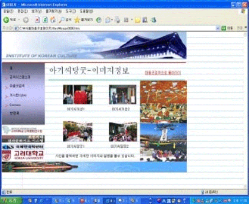
This map is an electronic cultural Atlas of the Joseon Dynasty established by the Korea University Institute of Ethnic Culture. When you search Gwacheon and Uiwang Village Gut, which belong to Indeokwon-gil, one of the old roads in Gyeonggi Province, you will see geographical information about Village Gut, which used to live in Hakhyeon Village in Uiwang. Along with geographical information, information about village gut appears as follows (Fig. 3).
III. COLLECTING TARGET DATA, PROCESSING DATA AND ESTABLISHING
The task to be pre-determined in producing electronic cultural maps of old roads in Gyeonggi Province is to collect target data.
Data on old roads in Gyeonggi Province, including the existing Gyeonggiyetgil-Website and the Gyeonggiyetgil-App, should be collected from Gyeonggi Memory, Gubi (Oral) Literature World, Local Culture Exhibition, and Joseon Electronic Culture Map. The period of data shall be from the Joseon Dynasty to modern times. In order to process data, a list of data shall be prepared, data collected, and how this data shall be processed shall be considered.
The collected data processing method is selected through the identification of users of the Gyeonggi-do Electronic Culture Map. Users of electronic cultural maps on old roads of Gyeonggi-do may be divided as follows: It can be divided into groups of ordinary users who look at the Gyeonggiyetgil-Website, users who actually travel on foot using the Gyeonggiyetgil-App, and researchers or experts who want to get more professional and extensive data on Gyeonggiyetgil.
For users of the Gyeonggiyetgil-Website, general data on the Gyeonggiyetgilis provided. Data from the Gyeonggiyetgil-Website already produced can be used.
The size of the original file shall be reduced in consideration of the area of devices, the capacity of mobile devices, etc. where data can be viewed in the mobile environment.
The data provided in the Gyeonggiyetgil Electronic Culture Map for researchers and experts should be processed with the quality as close to the original as possible. Analog data shall be digitally processed and descriptions of data shall be recorded.
By processing the collected data, you can make a theme map related to Gyeonggi Old Road. For example, if you create a theme map called ‘Gyeonggiyetgil and Village Gut (shaman ritual)’, you can collect related data and process the data according to the following field guidelines. First, text data DB can process data according to the following guidelines. The database tool can use Microsoft Access. Take a look at the Table 1 below.
This information cannot be found on the Gyeonggiyetgil-App or the Gyeonggiyetgil-Website. As such, information related to the old road of Gyeonggi Province is scattered in various places, and considering the spatial and historical characteristics of the old road of Gyeonggi Province, it is necessary to establish an electronic cultural map that can provide information related to the old road.
Map, the theme map of the Joseon Dynasty Electronic Culture map. It is necessary to collect and review data related to the old road of Gyeonggi Province in the future. It shall be deemed that data shall be classified by subject matter and the characteristics of the relevant data shall be reviewed and the data shall be processed by preparing field input guidelines.
In addition, there will be video, photo, and voice data. These materials will also require the principles of DB and metadata creation for deployment according to the topic map. This study first presented type data under the theme of “Gyeonggiyetgil and Village Gut,” which is highly feasible in the Gyeonggiyetgil lElectronic Culture Atlas. Let’s take a look at the table below.
IV. THE BASIC CONCEPT OF INFORMATION PROVISION
The Gyeonggiyetgil Electronic Culture Atlas shall be designed to enable users to obtain information as necessary. Users will be researchers and ordinary people. Maps for researchers should be able to link various topics. In the case of ordinary users, they shall be divided into users who use web pages using PCs and users who use mobile devices.
Theme chart called “Gyeonggiyetgil and Village Gut” is produced, relevant data may be collected and processed in accordance with the following field guidelines: First of all, the text data DB can process the data according to the instructions below. Microsoft Access is available for database tools.
The table above is revised to reflect the characteristics of the Gyeonggiyetgil Electronic Culture Atlas which was used to process the data of the Village Gut.
The collected data may be processed to produce a theme chart related to the old road of Gyeonggi-do. For example, if a Images includes all images related to the old road of competition. Images include photos, paintings, and map scans. For researchers users, high-quality images should b Be provided, and for mobile users, images should be serviced by reducing file size on old roads due to small screens and capacities. The extension of the image is unified into JPG.
All video data related to the old road of Gyeonggi-province are collected and provided. It includes all videos such as YouTube videos related to old roads in Gyeonggi Province, personal production data, media production videos, institutional production videos, VR, and the others. The capacity of data shall be adjusted according to the general public, mobile users, experts, etc. In the case of images, high-definition images are large in size, so low-definition edits are recommended for materials provided to the general public and mobile users. In principle, videos for experts shall be provided without modifying the size of the original.
Theme chart called “Gyeonggiyetgil and Village Gut” is produced, relevant data may be collected and processed in accordance with the following field guidelines: First of all, the text data DB can process the data according to the instructions below. Microsoft Access is available for database tools.
The table above is revised to reflect the characteristics of the Gyeonggiyetgil Electronic Culture Map (Byun Jisun: 2007), which was used to process the data of the Village Gut.
It provides interview sound sources related to Gyeonggi Old Road, Gyeonggiyetgil’s folksongs, legends, folktales, and myths. Currently, voice data exist in Gyeonggi Memory, Local Culture Exhibition, and Gubu(Oral) Literature World, so it can be collected and processed. In particular, there are folksongs of old roads in Gyeonggi Province, voice data of old literature, and voice information files of old roads in Gyeonggi Province. Voice data is converted to a wav file or mp3 file.
It provides print data related to the old roads of Gyeonggi-province. Stories related to the old roads of Gyeonggi-do, transcriptional materials of Gubi literature voice materials, relevant literature, and references are provided.
If the Gyeonggiyetgil Electronic Culture Atlas provides simple information, the Gyeonggiyetgil Electronic Culture Atlas provides various information on specific points in various forms. For example, information on a specific region may be provided through voice and text and video. The biggest feature of the Gyeonggiyetgil Electronic Culture Atlas is that various information in the geography and culture fields on a specific point on the map are ‘layered’.
Reference materials for providing video information are as follows [4].
References for text information are as follows [5].
Reference materials for providing image information are as follows [6].
Reference materials for providing sound information are as follows [7].
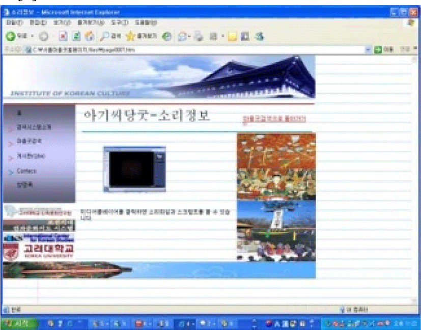
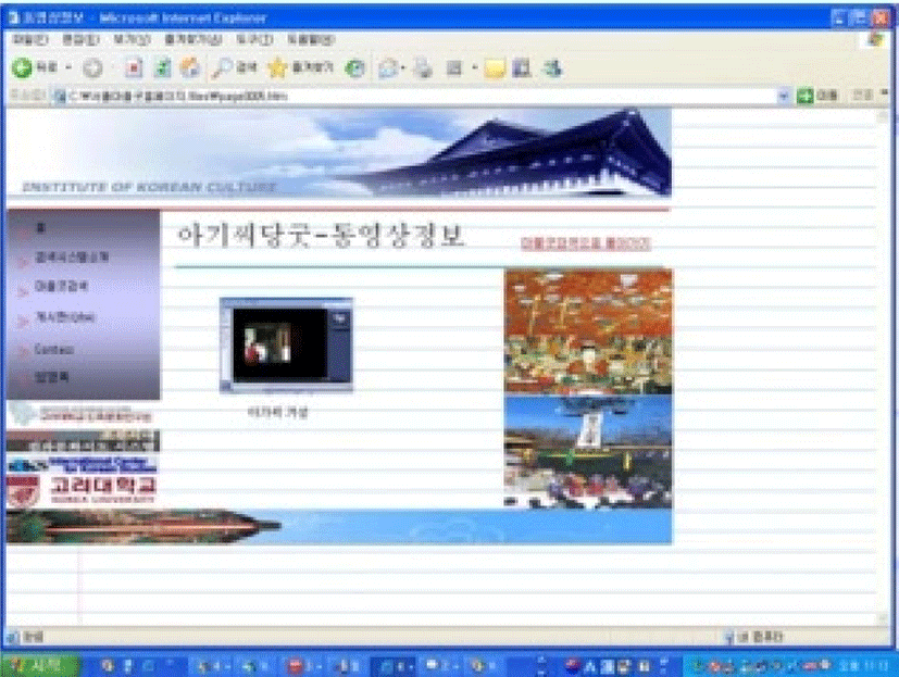
The construction of a virtual prototype of the Gyeonggiyetgil Electronic Culture Atlas can be constructed by referring to the ‘Seoul Village Gut Electronic Culture Atlas Search System’ created by Jisun Byun. Examples of providing geographic information, sound information, image information, video information, and document information in Jisun Byun’s system are as follows [1].
V. CONCLUSION
This article is intended to examine the need for electronic cultural guidance and the basic concept of providing information on This paper’s old road to Gyeonggi Province. In order to examine the basic concept of information concepts, the process of collecting and processing data related to the old road of Gyeonggi-province was presented.
This paper first presented a method for collecting text data and establishing a database necessary to create a theme map called ‘Gyeonggiyetgil and Village Gut’, which is a theme map related to the old road of Gyeonggiyetgil.